Description
Mountaineering as an activity has been known to mankind since the first tryst with the mountains was made. Since time immemorial, sages and pilgrims have been drawn to these mountains because they provide not only serene sheds of solitude, but their very sight uplifts the spirit and makes it soar, fulfilling the longing for the Infinite that is both beyond and yet within the human soul. The Himalayan Mountains are no exception to this longing.
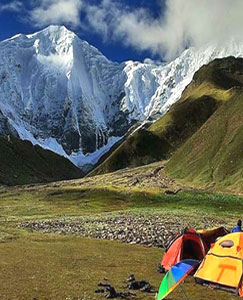
Holiday-makers can make the most of these mountains, which are a playground for many an enjoyable holiday activity. Trekking, high altitude camping, mountain biking, rock climbing and skiing in the winter months are some of the many holiday activities offered, and the State Tourism Board is doing all it can to make Uttarakhand the adventure capital of the country. Nature-lovers and photographers can invigorate their passion with the plush flora and fauna of this kingdom of nature that boasts of thousands of species, some of which can only be found in this lap of the world. The importance of eco-friendly diversity has been noted and this is why forest institutes in the region promote the learning and discovery of new species with an emphasis on the preservation of existing ones.
Nanda Devi East
Resting majestically in the Garhwal Himalayas is a twin-peaked massif that forms a long high ridge leaning east to west, known as Nanda Devi. The Nanda Devi East Peak is part of this, and together with the West Peak, are formed the twin peaks of the Goddess Nanda.
A barrier ring guards the main summit, within which can be found some of the highest mountains in the Indian Himalayas, and Nanda Devi East is one of them. Twelve peaks surpass 6,400 meters in height. The heart of the insurmountable ring is the Nanda Devi Sanctuary which is protected as the Nanda Devi National Park. Nanda Devi East lies on the eastern edge of the ring and of the Park; at the border of Chamois, Pithoragarh and Bageshwar districts. The Nanda Devi West Peak towers at 7,817 meters and is the second highest in the country. Climbing – expeditions are best taken up in the months of May, June, September and October.
Satopanth Glacier
Satopanth Tal is an untouched glacier lake at an altitude of 15100 ft. With the shape of a triangle, it is hidden amidst the majestic Garhwal region. Satopanth Lake has a very rich history. It is considered to be a religious place for the locals. It is believed that the trimurthis (triple deity of the divinity in Hinduism), Brahma, Vishnu, Maheswara meditated on its three corners. Some articles say that at the end of the Mahabharata, Pandavas took the route from Mana village to reach the steps to heaven which is on the Swargarohini glacier via Satopanth Tal.
The trail to Satopanth lake is one of the beautiful trails in the Garhwal region. You cross Mana, India’s last village, the famous Vasundhara waterfall. Sahastradhara which has more than 100 waterfalls can be spotted on the trail. Trekking on the bank of Alaknanda and camping in the Lakshmi van forest and Chakratirtha meadow are the best part of the trek. The lake is surrounded by Mount Chaukhamba, Mount Neelkantha, Mount Swargarohini and Mount Balakun. All these snow-capped mighty mountains will be standing next to you.
Apart from religious significance Satopanth also become one of the Popular treks in Uttarakhand. This glacier trek offers majestic views of Himalayas.
Milam Glacier
Milam glacier is the major source of the River Gori Ganga which originating from Tirsuli and the southern slope of Kohli, Milam glacier is a truly magnificent trekking destination in the Kumaon Himalayan region. Milam Glacier trek passes through several solitary hamlets, lush green alpine meadows dotted with wild flowering plants, evergreen whispering, and raging forest and varied landscape simply grab the imagination of every explorer. Milam is one of the moderate to challenging treks in the Kumaon Himalayan region that takes almost a fortnight to trek. The trailing track to Milam Glacier commences from the month of May and the odyssey winds up in the mid of October. The Milam Glacier trek takes approximately 10 – 15 days of trail and trekkers from Munsiyari to Munsiyari. The actual trek to Milam Glacier starts from Bog Udyar, which is a drive-able distance from Munsiyari. Milam glacier trek is a moderate level trek.
Neelkanth Peak
Popularly known as the Queen of Garhwal, Neelkanth is a beautiful snowy peak towering above the holy town of Badrinath. The history of Central Garhwal would remain unfinished without mentioning this peak of supreme splendour and exquisiteness. The elegant Neelkanth borders the Nar-Narayan range of mountains and is abundant in all the beautiful gifts Nature has to offer.This snowy mountain lies at an altitude of 6,597 metres and looks upon the Badrinath shrine. Neelkanth is a sought-after destination for devout pilgrims.
Trishul
Named after the trident of Lord Shiva, Trishul is the group of three imposing peaks of western Kumaon near the Bageshwar district. The main peak, Trishul I, is notable for being the first peak over 7,122 metres to have ever been climbed way back in 1907. Trishul II and Trishul III were first climbed in 1960 by a Yugoslav team from the Bidalgwar Glacier, scaling the supreme heights of Trishul II from the southern ridge and Trishul III from the northern ridge. Before ski tourism gained popularity as a winter sport in Auli, Trishul was amongst the few peaks that were used as training spots for ski-equipped patrolling officers of the Indo-Tibetan Border Police Force. It is reported that an expedition to scale the peak in 1958 took the mountaineers four whole days to climb and a mere 90 minutes to ski down to their base camp. The gorgeous Roopkund Lake rests at the bottom of these slopes, which is also known as the Mystery Lake since around 600-odd skeletal remains of horses and humans were once found here. The best views of Trishul are to be seen from Kausani and Bedini Bugyal.
Shivling
The lofty Shivling Peak is perhaps one of the most imposing peaks in the Garhwal Himalayas, positioned at an altitude of 6,543 metres. This important Himalayan mountain range and can be accessed through the Chaturangi Vamak route. The mountain actually has two summits and rises like a pyramid above the snout of the Gangotri Glacier. Its impressive appearance has often been compared to the Matterhorn in the Alps. Between Gaumukh and Shivling, is the mesmerizing Tapovan meadow which is also a well-known pilgrimage site. The Shivling Peak is surrounded by rocky terrain on three sides. The west side of the peak slopes moderately and this is where snow accumulates. It forms the western gateway for the lower Gangotri Glacier and is a popular climbing peak today, owing to its easy accessibility.
Chaukhamba
One of the chief mountain massifs in the Gangotri cluster of mountains in the Garhwal Himalayas is the magnificent Chaukhamba peak. ‘Chaukhamba’ literally means ‘four pillars’ and its four impressive peaks rise up to an elevation of 7,138 metres, 7,088 metres, 6,995 metres and 6,854 metres respectively. The highest peak in the group is Chaukhamba I that lies precisely on top of the Gangotri Glacier and forms the eastern connection of the group. Excellent views of the Chaukhamba can be seen from a place called Guptakashi and the Vasuki Tal Lake that is situated at an altitude of 4,150 metres above sea level. The Gangotri Glacier begins on its western slopes and is one of the largest in the Himalayas. The slopes of Chaukhamba are ideal for major mountaineering expeditions and the best months for climbing are June, July, August and September. The Shivling Peak is also an important part of this group.
Bhagirathi Peak
Bhagirathi is also the name given to the upper part of the Ganga. Both the mountain and the river are said to be named after King Bhagirath, who supposedly coerced Goddess Ganga to descend from the heavens in the form of a raging torrent as an answer to his severe and unwavering austerities. The Bhagirathi Glacier in the upper Alaknanda basin, along with other glaciers like the Satopanth Glacier, is the source of the River Alaknanda. These glaciers are located at a distance of 17 kilometres from the renowned temple of Badrinath, in the district of Chamoli. They begin in the Chaukhamba and Badrinath cluster of peaks, which separate them from the Gangotri group of glaciers. Bhagirathi can be reached from Joshimath in the sub-division of Chamoli, by following the Badrinath and Mana motorable road. From the village of Mana, the route trails the path of the River Alaknanda. A 145-metre waterfall known as Vasundhara lies on the right bank of the Alaknanda and is perched at a height of 3,250 metres. Major mountain expeditions can be enjoyed in the months of May, June and September.
Swargarohini
The lofty Shivling Peak is perhaps one of the most imposing peaks in the Garhwal Himalayas, positioned at an altitude of 6,543 metres. This important Himalayan mountain range and can be accessed through the Chaturangi Vamak route. The mountain actually has two summits and rises like a pyramid above the snout of the Gangotri Glacier. Its impressive appearance has often been compared to the Matterhorn in the Alps. Between Gaumukh and Shivling, is the mesmerizing Tapovan meadow which is also a well-known pilgrimage site. The Shivling Peak is surrounded by rocky terrain on three sides. The west side of the peak slopes moderately and this is where snow accumulates. It forms the western gateway for the lower Gangotri Glacier and is a popular climbing peak today, owing to its easy accessibility.
Booking Form